
New Evidence #2 – Jackson County Land
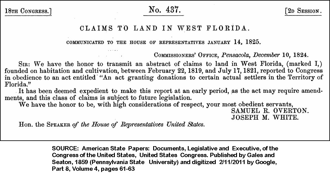
When we begin digging through early papers trying to sort out who was living in the area of James B.’s homestead during the years Britain, Spain, France, the United States, and the Indians were transferring ownership of the land from one Nation to another, we find the first land claims in West Florida (Figure 4) being presented to U.S. Congress in 1824.
Figure 4 – West Florida Land Claims
Click image for larger view.
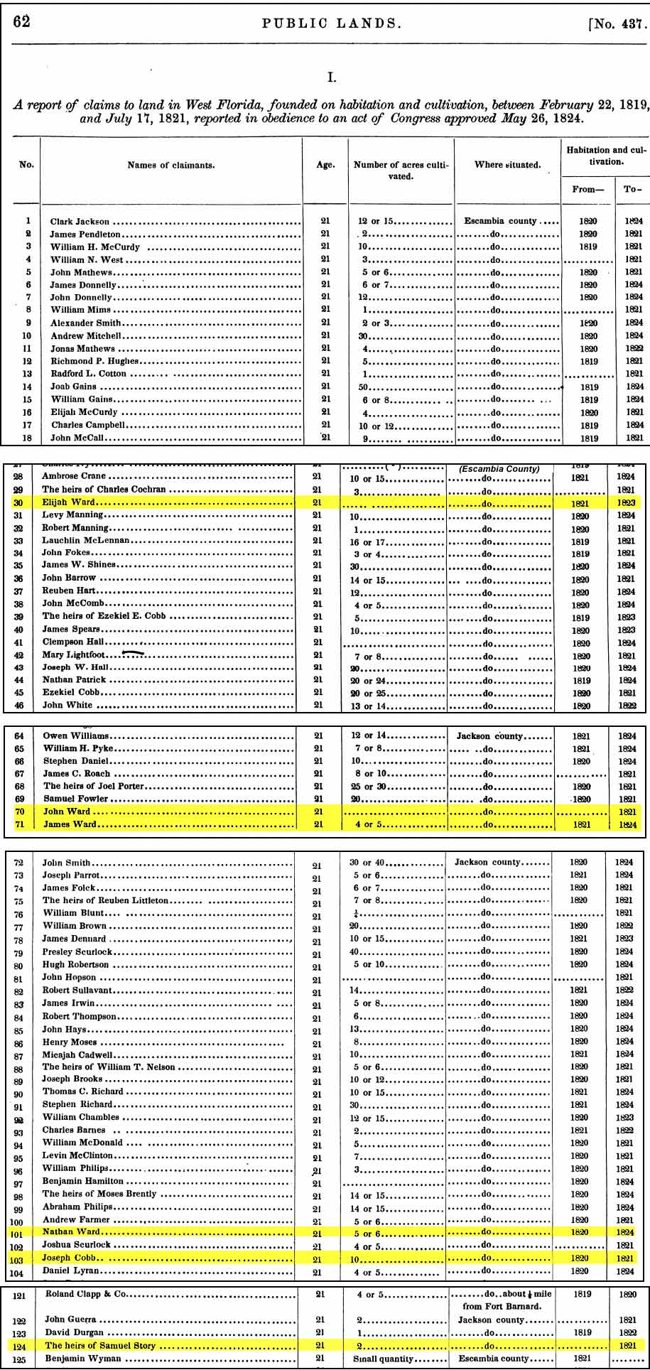
The list of people with West Florida land claims is attached this letter (Figure 4) from Pensacola to the House of Representatives. It is several pages long and has been cut into sections in Figure 5 to highlight key names:
Figure 5 - Florida Public Lands 1819-1821
Click image for larger view.
On this list we find the names of the same three Wards we found in 1820:
- John Ward
- Nathan Ward
- James Ward
We also find the following names:
- Elijah Ward (living in Pensacola) – family lore says he was either a brother or cousin of our James B. Finding James and Elijah living in what had been Spanish West Florida puts both of them in the same place very early in their lives.
- The heirs of Samuel Story – Sam Story was the Chief of the Uchee Town who died and was buried along the Bruce River. The story says his tribe buries him and moves south. Obviously, not all of his tribe moved because his heirs filed a land claim.
Did you notice these land claims were for either Escambia or Jackson Counties? Also, the date on the letter is 1825 and the 18th Congress occurred in 1825.
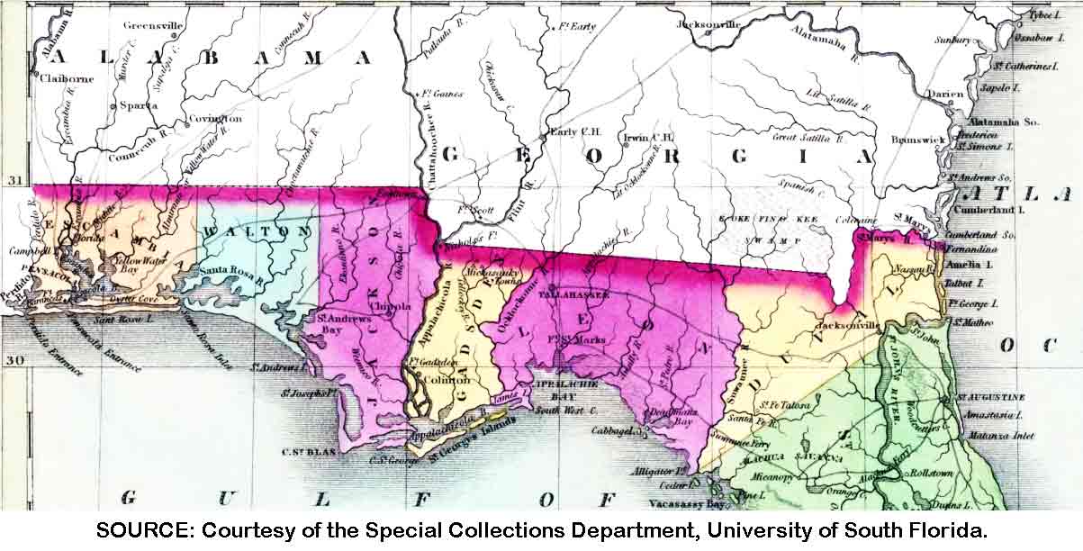
Figure 6 provides a map showing how West Florida was divided three years later, in 1827:
Figure 6 - Florida Counties 1827
Click image for larger view.
In 1827 Florida included the counties of Escambia, Walton, Jackson, Gadsden, Leon, and Duval. The green marks the beginning of St. Johns County which extended south to the Keys.
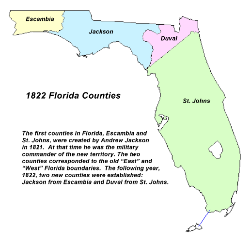
Just 6 years before this map in 1821, Florida had only 4 counties – which matches the county names on the PUBLIC LAND claims document (see Figure 7):
Figure 7 - Florida Counties 1822
Click image for larger view.
Because of the rapid change in county lines, it is unclear exactly where in West Florida these Jackson County land claims originated. Since the list only gives Escambia and Jackson as county names, it appears to refer to the 1822 map – and not the 1827 map (which was in effect when the land claims are finalized).
Based on this information, it appears there should be a “paper trail” spanning at least 5 years (between 1822 and 1827) starting with the collection of this information, its verification, and presentation to the United States Congress in 1825. Digging in the State of Florida Archives, we find a microfilmed book, which does not appear to have a title, but does contain land claims. Figure 8 show the hand-written land claim for John and James Ward. The claim for Nathan Ward appears on a different page and transcribed below.
Figure 8 - Florida Public Land Claim, Page 116
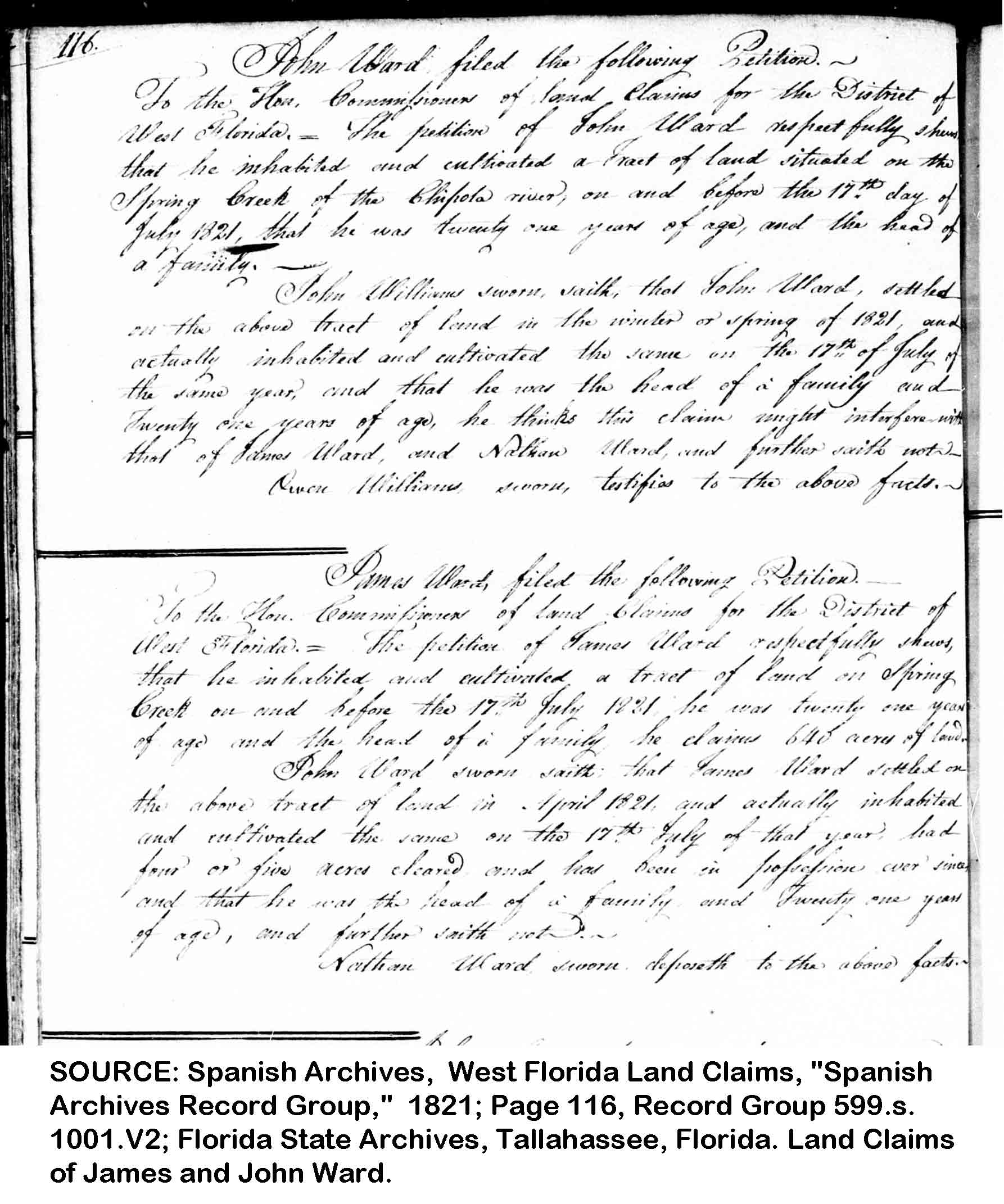
Click image for larger view.
Figure 8 shows Page 116 of a handwritten, untitled book documenting land claims in West Florida, it says:
John Ward filed the following Petition -- To the Hon. Commission of land claims for the District of West Florida. The petition of John Ward respectfully shows that he inhabited and cultivated a tract of land situated on the Spring Creek of the Chipola river, on or before the 17th day of July 1821, that he was twenty one years of age, and the head of a family.
John Williams sworn, saith, that John Ward, settled the above track of land in the winter or spring of 1821, and actually inhabited and cultivated the same on the 17th of July of the same year, and that he was the head of a family and twenty one years of age, he thinks this claim might interfere with that of James Ward, and Nathan Ward and further saith not.
Owen Williams sworn, testifies to the above facts.
James Ward, filed the following petition to the Hon. Commissioner of land claims for the District of West Florida. -- The petition of James Ward respectfully shows, that he inhabited and cultivated a tract of land on Spring Creek on and before the 17th July 1821, he was twenty one years of age and the head of a family he claims 640 acres of land.
John Ward sworn saith that James Ward settled on the above tract of land in April 1821 and actually inhabited and cultivated the same on the 17th July of that year had four or five acres cleared and has been in possession ever since, and that he was the head of a family and twenty one years of age, and further saith not.
Nathan Ward sworn deposeth to the above facts.1
Further in this book, on page 130, we find:
Nathan Ward, filed the following Petition -- To the Hon. Commissioner for Ascertaining Claims and Titles to Lands within the Florida. The Petition of Nathan Ward respectfully represents that he was the head of a family, and twenty one years of age Claims title to 640 acres of land lying on Spring Creek and bounded by John Wards Claim on the North, and on the South by William Philips Claim, and on the West by Andrew Farmer's Claim, under an act entitled an act granting Donations of Lands to certain actual settlers in the Territory of Florida, which said tract of land was actually inhabited and cultivated by your Petitioner previous to 17th July 1821, a Report to Congress under the favour of actual settlers.
Benjamin Hays sworn saith, that Nathan Ward, settled on the above track of land in 1820, and actually inhabited and cultivated the same on the 17th July 1821 and has continued cultivation ever since, had five or six acres cleared and under cultivation and that he was the head of a family and twenty one years of age. This claim will interfere with William Philips and John Ward, and further saith not.
John Ward sworn, deposeth to the same facts.2
Unfortunately, the entries in this book are not dated. On page 230 we find a handwritten chart with basically the same information in the typed chart shown above (Figure 5) which was presented to Congress in 1824. In this same microfilmed record collection, there is a note saying the West Florida Folder was lost. Most likely, this folder would have contained additional information regarding the property line conflicts between the Wards.
At first look, several things seem odd about the above sworn statements. Was everyone exactly 21 years old? What was so important about July 17, 1821?
The United States signed the Adam-Onis Treaty with Spain on February 22, 1819 – which provided for the transfer of Florida to the United States. However, the actual transfer didn’t occur until after the treaty was ratified by Congress and Spain formally transferred FL to the US in Pensacola, FL on July 17, 1821. An “exchange of flags” ceremony took place on July 10th in St. Augustine (East Florida) and on July 17th in Pensacola (West Florida) with Florida Territorial Governor Andrew Jackson presiding.
That means July 17, 1821 is the “official” date Florida became a United States Territory.
The acquisition of Florida provided the United States with more than 30 million acres with only a handful of settlers, poor roads, and a large Indian population. In order for the new Territory to thrive, it had to increase its population, infrastructure (roads & transportation), and revenue. It also had to overcome the clouds of mosquitoes, snakes, alligators and other undesirable swamp inhabitants. Under the Adams-Onis Treaty the United States agreed to recognize valid Spanish land titles. Congress created a board of commissioners for Pensacola (West FL) and St. Augustine (East FL) to adjudicate the claims.
Congress also passed a DONATION ACT in 1824 to grant squatters valid titles to a maximum of 640 acres. This act permitted persons who were neither wealthy nor capable of establishing large-scale agricultural enterprises to settle in Florida. James, John, and Nathan Ward, along with many others, took advantage of this Donation Act and filed their claims. Here is the full text of this Act:
DONATION ACT
Chap. CLXIV - An Act granting donations of land to
certain actual settlers in the territory of Florida.
Be it enacted by the Senate and House of Representatives of the United States of America, in Congress assembled, That the commissioners for ascertaining titles and claims to lands in Florida, be, and they are hereby, authorized and required, within their respective districts, and in addition to their former duties, to receive and examine all claims that may be presented to them, and the evidence in support of each of such claims, founded on habitation and cultivation of any tract of land, town, or city lot, or out-lot, by any person, being the head of a family, and twenty-one years of age, who, on the twenty-second day of February, one thousand eight hundred and nineteen, actually inhabited and cultivated such tract of land, or actually cultivated and improved such lot, or who, on that day, cultivated any tract of land in the vicinity of any town or city, having a permanent residence in such town or city, in said territory; and to grant certificates of confirmation for any tract of land thus inhabited and cultivated, or cultivated by any person of the above description, residing in any town or city in the vicinity of the tract so cultivated; which land shall be located in an entire body, as nearly as possible, in conformity to the surveys of the contiguous public lands, and so as to embrace the principal improvements then made on any tract so claimed, and shall not exceed in quantity six hundred and forty acres: And it shall also be the duty of said commissioners to receive claims to land founded on habitation and cultivation, commenced between the twenty-second of February, one thousand eight hundred and nineteen, and the seventeenth of July, one thousand eight hundred and twenty-one, when Florida was surrendered to the United States, and evidence in support of the same; and to report an abstract of all such claims to Congress, and of the claims by them confirmed, to the Secretary of the Treasury; and the claims merely reported on, shall be laid before Congress at their next session, with the evidence of the time, nature, and extent, of such inhabitation and cultivation, in each case, and the extent of the claim: PROVIDED, that no claim shall be received, confirmed, or reported, to Congress, by the said commissioners, for confirmation, in favour of any person, or the legal representatives of any person, who claims any tract of land in said territory, by virtue of any written evidence of title derived from either the British or Spanish government.
Approved, May 26, 18243
Based on this, James, John, & Nathan were required to:
- be 21 years old (or older)
- be the head of a family
- If a resident ON February 22, 1819:
- inhabited or cultivated the land they were claiming, or
- cultivated other land in the vicinity of a town where they had permanent residence.
- If not a resident on February 22, 1819:
- established residence BEFORE July 7, 1821, and
- have made changes to the land BEFORE July 7, 1821
- not have a British or Spanish Land Claim.
We already know Nathan, John, and James were residents on July 4, 1820 because they paid taxes in Jackson County. Which means they met the “if not a resident on February 22, 1819” requirements. But we don’t know if they were living in Jackson County before February 22, 1819, so they may have met both.
Did John, James, and Nathan receive their claim? In 1827, the same year Congress finalized their claim, they went to the local land office and officially filed their claims. Below are the Public Land Office records showing these transactions.
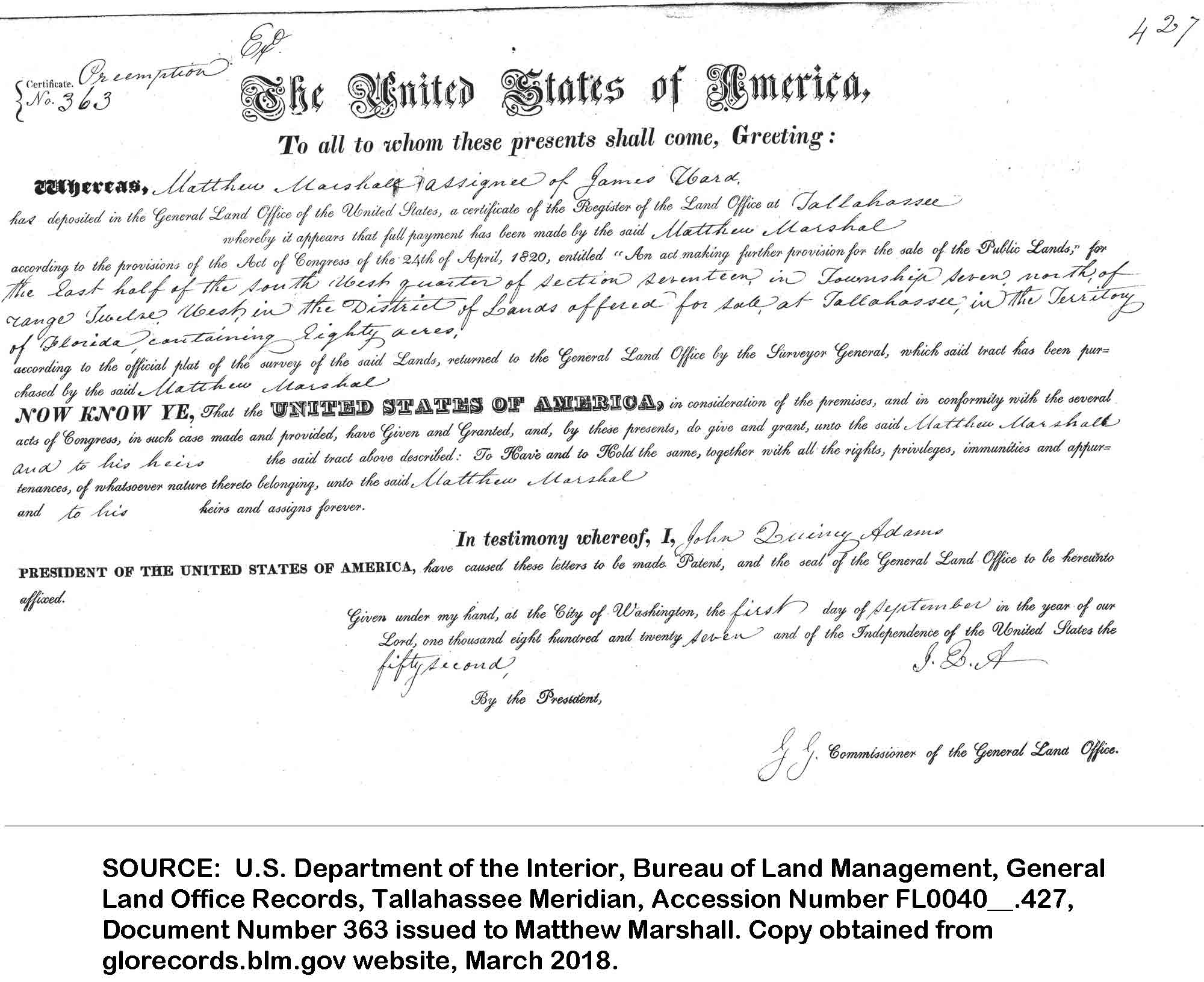
- Land Patent #363 (Figure 9), dated 9/1/1827, Twp 7N Rng 12W E ½ SW ¼ Section 17, Tallahassee Land Office - Matthew Marshal, “assignee of James Ward” purchases land identified as Township 7N, Range 12W, Section 17, east half of the SW quarter. While placed within the boundaries of Jackson County, FL in 1827, the boundaries changed due to a survey error and it is now within the boundaries of Houston County, AL (near Madrid, AL and north of Graceville, FL). The term “assignee” as used here means James Ward sold or traded the land to Matthew Marshal by giving him his paperwork (land title). Then Matthew Marshal took the paperwork to the land office and officially claimed this land (and became the first official land owner).4
Matthew Marshal also made another land purchase on the same day (9/1/1827, Land Patent 364). He bought Township 7N, Range 12W, Section 35, W ½ NE ¼, in Jackson County, FL.
The end result of this transaction is Matthew Marshal now owns land on three sides of John Ward’s land. Together, John Ward and Matthew Marshal own 640 acres – with Matthew owning ¾ and John only ¼.
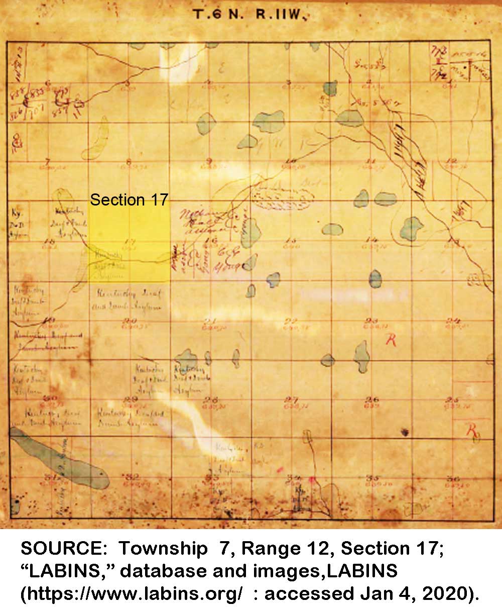
The 1825 Survey Field Notes for Township 7, Range 12, Section 17 notes “poor pine land” for this area. Surveyors were instructed to make field notes indicating the nature of the land, streams, and other key features, especially those important to future farmers. The note “poor pine land” would indicate it was undesirable for farming.5
Figure 9 - Land Patent #363
Click image for larger view.
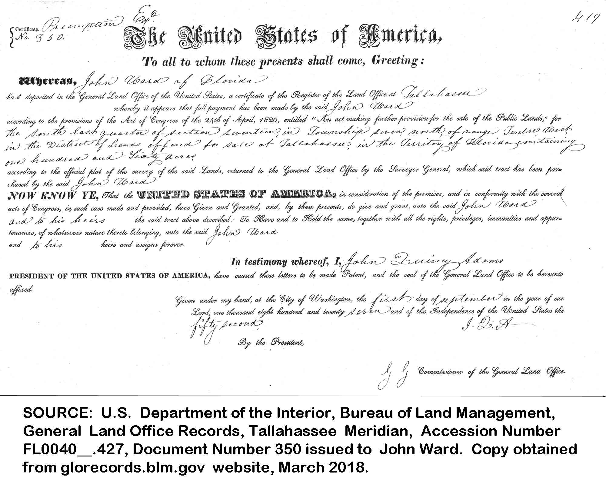
- Land Patent #350 (Figure 10), dated 9/1/1827, Twp 7N Rng 12W SE ¼ Section 17, Tallahassee Land Office6 – John Ward pays cash for land identified as Township 7N, Range 12W, Section 17, southeast quarter. While placed within the boundaries of Jackson County, FL in 1827, the boundaries changed due to a survey error and it is now within the boundaries of Houston County, AL (north of Graceville, FL).7
It is unknown how the local land office would have recorded a Donation Act deed. If John Ward was granted land via the Donation Act, he most likely received a certificate or other paperwork which he needed to take to the Land Office to finalize his claim. It eventually became a common practice for individuals to “sell” these certificates, which the buyer would take to the Land Office to register. These transactions normally say the land owner’s name and the buyer as their “assignee.” The end result is the land is officially registered in the buyer’s name. Keep in mind, “public land” – which was owned by the United States -- could only be purchased once – and that transaction also transferred management of the property from the United States to the State. After the sale, it was the responsibility of the State to maintain ownership records on that land.
John Ward purchased this property by paying cash – not using a certificate.
Figure 10 - Land Patent #350, John Ward of FL
Click image for larger view.
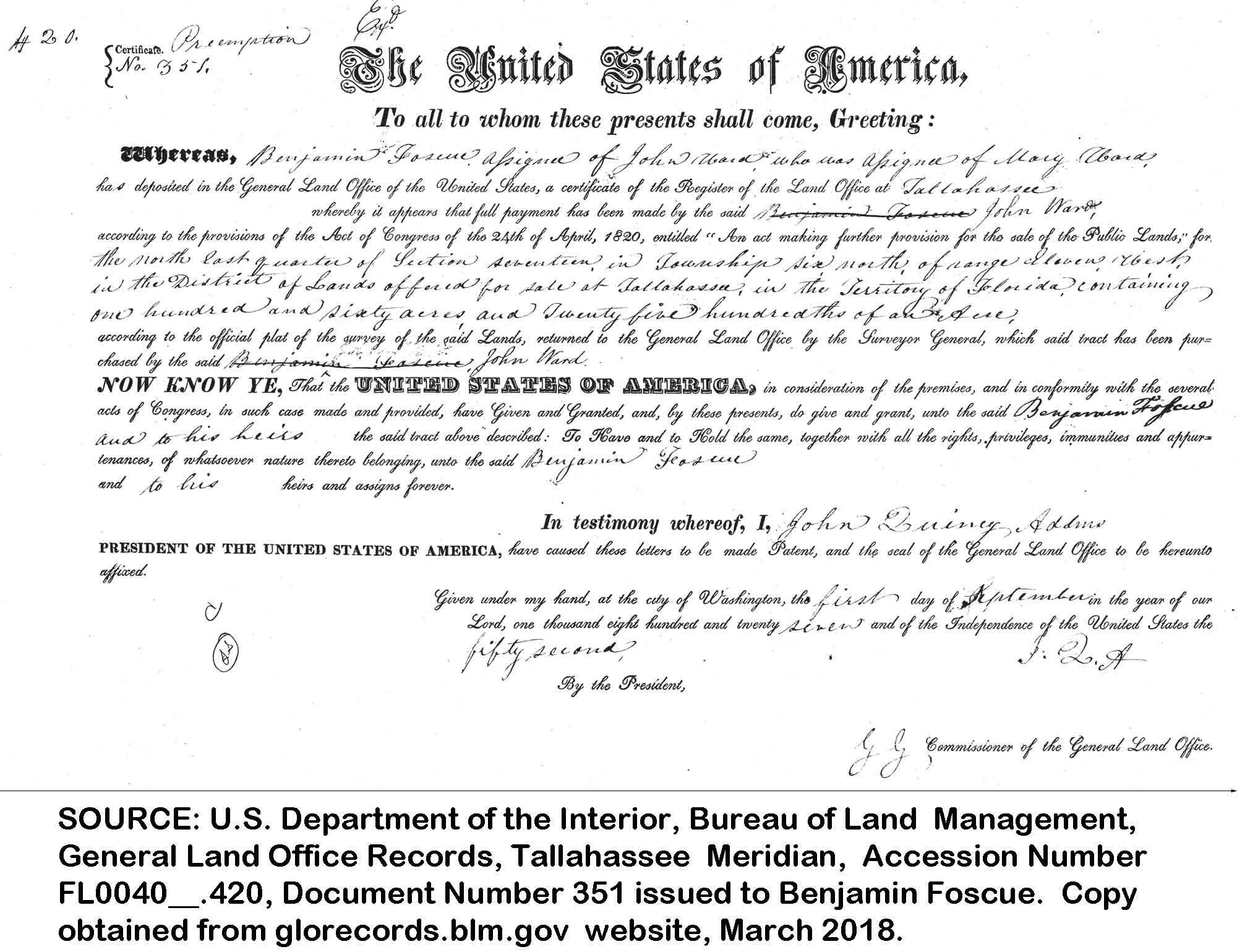
- Land Patent #351 (Figure 11), dated 9/1/1827, Twp 6N Rng 11W NE ¼ Section 17, Tallahassee Land Office – Benjamin Foscue, “assignee of John Ward who was the assignee of Mary Ward” purchases land identified as Township 6N, Range 11W, Section 17, northeast quarter. This property is slightly NW of present-day Marianna, FL and east of Campbellton, FL and Jacob City, FL. The term “assignee” as used here means John Ward sold or traded the land to Benjamin Foscue by giving him his paperwork (land title). He “signed over” the land title to Benjamin Foscue who then filed it at the Land Office.8
This document also implies John Ward could be the SON of Mary Ward – who must be a widow (otherwise her husband would be completing the sale of their land). However, John Ward could also be a trusted relative – such as a brother-in-law or brother. Could Mary be Nathan’s wife?
The end result of this transaction is Benjamin Foscue owns the land.
Figure 11 - Land Patent #351
Click image for larger view.
In 1825 the interior of Section 17 was not surveyed which means there are no field notes indicating the type of land. However, the Plat Map (Figure 12) identifies “Shurlocks River” and “Shurlocks Spring Creek” as flowing together in the southern half of Section 17 and forming Dry Creek. Today, Shurlocks River is called Spring Branch & Marshall Creek. Shurlocks Spring Creek has disappeared and Duck Pond stands where it once flowed. The Plat Map also shows the Kentucky Deaf & Dumb Asylum is buying up much of the land in this area – which would have made it difficult to purchase adjoining land and expand an individual’s acreage in the future.9
Figure 12 - 1825 Survey Township 6N, Range 11W
Click image for larger view.
Benjamin Foscue made this purchase on September 1, 1827 and made an additional 5 purchases during 1827. The only other name listed as “assignee” was John McElroy. Between 1824 and 1827 he makes four more purchases and all of them were in Jackson or Gadsden County, FL or Marengo County, AL. Other “assignees” were Levin Hainsworth, Israel Pickens, and Lavender Simmons.
Could Benjamin Foscue be an attorney or legal representative for a company sent to buy up as much land as possible – maybe the Kentucky Deaf & Dumb Asylum? By 1840 he has made 24 more land purchases – of which there is only one with an “assignee” (Allen Glover). These later purchases are in Coosa and Tallapoosa Counties, AL.
Digging a little deeper, we learn Benjamin Foscue was born in Jones County NC in 1789 and died in Jefferson County, TX shortly after moving there in 1850. During his life he lived in Jackson County, FL and Coosa, AL. He also served in the war during 1812. One of his sons, also named Benjamin Foscue, is later elected to the Texas House of Representatives.
The General Land Office does not have a Land Patent in this area for anyone named Nathan Ward. Most likely, his land was also sold, but not recorded as “assignee of Nathan Ward.” Most likely the transaction for Mary Ward is the sale of Nathan’s land. His wife’s name is Mary.
The following map shows the location of each of these land tracks. From this we learn John and James owned land beside each other and Mary Ward (possibly Nathan) owned land about 10 miles away. If John, James, and Mary (possibly Nathan) were related, why didn’t they own land closer together? One possible reason has to do with driving cattle. It would be beneficial if these areas were along a path heading to market – that way they could rest their cattle at each homestead.
It is unknown if this is what they were doing. However, the fact that all of them settled on “poor pine land” indicates they were probably grazing cattle.
One other point of interest – in the upper left corner of Figure 13 showing these Jackson County Land Claims you will see Slocomb, AL. James B.’s homestead in the 1850s is a few miles NORTH of Slocomb, AL near Malvern, AL. We now know James B. Ward was living in North Florida in 1820 when he was 24 years old and, when he died in 1861 at the age of 65, he was living less than 20 miles further northwest, above Slocomb, AL and near Malvern, AL. This map makes it easy to see he lived most of his life within a 20-mile radius.
Figure 13 - Location of Jackson County, FL Land Claims
![]()
Click image for larger view.
Notice the community of Campbellton lies half way between Mary Ward’s land and the land owned by John and James. The Indian town named “Chiscatalofa” was near here! It continued to be in this location until around 1836 – about 9 years after they sell their land. Could there be a connection?
Why, after petitioning the United States to keep this land, would they decide to sell? What changed?
One reason may have been the sudden increase in population. In 1820 Jackson County recorded 62 families. By 1825 the county reported over 200 families. Plus, the Kentucky Deaf & Dumb Asylum was purchasing land in the area making it difficult to purchase additional adjoining acreage in the future.10
An article in the May 18, 1827 edition of the Pensacola Gazette11 newspaper may provide other reasons. It says:
“LAWS OF FLORIDA. …..
An act to regulate our citizens trading with the Indians, and for other purposes therein mentioned.
WHEREAS, the safety, welfare and tranquility of the Territory of Florida, do in a great measure depend on the maintaining a good correspondence between the citizens of this Territory and the Indians in amity with the good people of the same, and whereas many inconveniences have arisen from private persons trading with them without licenses.
Be it enacted by the Governor and Legislative Council of the Territory of Florida, That for the better preventing disturbances among the Indians, by persons bartering with them in the woods or hunting within their limits, or many otherwise trespassing on the same, that from and after the first day of March next, it shall not be lawful for any person or persons to sell, truck, barter or exchange with any Indian or Indians, any rum or other strong liquors, clothing, arms, ammunition, or anything whatsoever in the woods, in their hunting grounds or within or settlements, or at any other place, other than at stores or houses licensed for that purpose, or shall hunt or trespass on the lands beyond the present boundary line. And every one so offending as aforesaid, shall forfeit any pay, upon legal conviction, before any court of this Territory, having jurisdiction of the same, the sum of five hundred dollars, good and lawful money, one half thereof to be paid to him, her or them, who shall sue for and prosecute such offenders to conviction, and the other half for the use of the Territory; and if such offenders shall not have sufficient effects whereon to levy such fine, then in every such case, the offender shall suffer corporeal punishment by whipping, not exceeding thirty nine lashes on the bare back, to be inflicted by order of the judge of the court at which such offender shall have been convicted, and the justices of the peace upon complaint made of any such offence, are hereby authorized and required to find over the offender by recognizance, with sufficient sureties, for his appearance at the next court having jurisdiction of the same, to answer such action or information as shall then be brought or exhibited against him, her or them, pursuant to this act, and for want of sureties, to commit such offenders to the common jail.”
This Law, would make it impossible for an Indian to live freely within the community. It is apparent the law was intended to keep everyone away from Indian Towns, but, the way it is written actually includes full and mixed-blood Indians living in the community! Anyone caught buying, selling, or trading with them would be fined $500, whipped 32 lashes on the bare back, or jailed.
Based on this new evidence, a more correct timeline for James B. Ward’s life would be:
- 1813 – GA: Hartford, Pulaski County - enlistment as a spy
- 1814 – GA: Hartford, Pulaski County - discharged
- 1815 – unknown
1815 – GA: Baldwin County - 19 yr old James Ward paid taxes- 1819 – FL: Jackson County – resident?
1820 – GA: Wilkinson County – Appears on census with wife and elderly woman1820 – James B. Ward’s father was dead by 1820- 1820 – FL: Jackson County – paid taxes
- 1821 – GA: Birth of first child, John Jackson Ward on Feb. 16, 1821
- 1821 – FL: Jackson County – Listed as resident on 1824 Land Claim which required him to be a resident in 1821
1822 – GA: James’ land on Nat’s Creek in GA is sold for fi fa- 1827 – FL: Jackson County – Signed Petition
- 1827 – FL: Jackson County – Sold land
- 1830 – AL: Dale County – Appears on census next door to John & Nathan Ward
- 1837 – AL: Dale County – James English estate settlement records
- 1840 – AL: Dale County – Appears on census
- 1850 – AL: Dale County – Appears on census and children are named
Items in bold are new or updated, and those with strike-through lines are no longer valid.
I think there is one possible explanation for why his first child was born in Georgia -- Elizabeth may have returned “home” and sought her mother’s assistance in delivering her first child.
FOOTNOTES
1 Spanish Archives, West Florida Land Claims, "Spanish Archives Record Group," 1821; Page 116, Record Group 599.s.1001.V2; Florida State Archives, Tallahassee, Florida. Claim of John and James Ward.
2 Spanish Archives, West Florida Land Claims, "Spanish Archives Record Group," 1821; Page 130, Record Group 599.s.1001.V2; Florida State Archives, Tallahassee, Florida. Claim of Nathan Ward.
3 United States Congress, The Public Statutes at Large of the United States of America, from the Organization of the government in 1789, to March 3, 1845. (1846; Boston, Massachusetts: Charles C. Little & James Brown, n.d.), IV: 47.
4 Certificate #363, Mathew Marshall assignee of James Ward; "Land Patents," database and images, General Land Office Records (https://glorecords.blm.gov).
5 Township 7, Range 12, Section 17; "LABINS," database and images, LABINS (https://www.labins.org/ : accessed Jan 4, 2020).
7 Certificate #350, John Ward of Florida; "Land Patents," database and images, General Land Office Records (https://glorecords.blm.gov : accessed 3/18/18).
8 Certificate #351, Benjamin Foscue, assignee of John Ward assignee of Mary Ward; "Land Patents," database and images, General Land Office Records (https://glorecords.blm.gov : accessed 3/18/18).
9 Township 6, Range 11, Section 17, 1825 Plat & Field Notes; "LABINS," database and images, LABINS (https://www.labins.org/ : accessed Jan 4, 2020). … Google Maps
10 Cox, History of Jackson County…. Township 7, Range 12, Section 17; "LABINS," database and images, LABINS (https://www.labins.org/ : accessed Jan 4, 2020).
11 Territory of Florida, "Laws of Florida," Pensacola Gazette, 5/18/1827, p. 1, col. 4-5; digital images, Newspapers (https://newspapers.com).